AM-CAN ROAD TRIP
The Magical History Tour, a coast-to-coast road trip taken during the Spring of 2007, for the purpose of allowing Steve to visit some of the places that played a part in the westward migration of his branch of the Van Slyke family tree, also provided opportunities for interesting stops and side-trips. Here are some of those highlights.
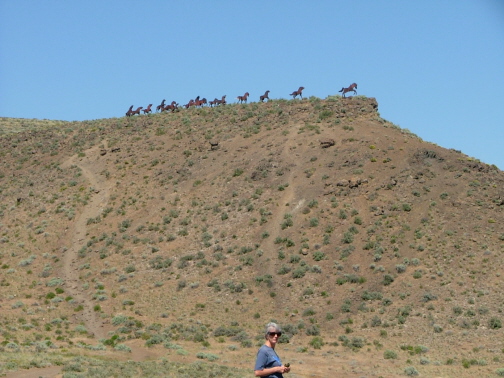
Our first stop on the first day on the road, to stretch our legs, was just after we crossed the Columbia River in eastern Washington. Kay stands in the foreground before a sagebrush covered bluff, topped with a herd of wild horses sculpted in metal.

.
Touring the site of the Battle of the Little Bighorn Monument in Montana, and hearing about the overwhelming opposition that Custer faced, but refused to acknowledge, makes the slaughter seem all the more tragic.
An estimated 10,000 Indians (that term seems to be coming back into vogue) were camped across the Little Bighorn River on the plains seen in this photo.
Custer had unwisely split his force of about 300 into three groups, one led by Captain Reno who attacked from the south (left) and was then forced to flee across the river and up this ravine.
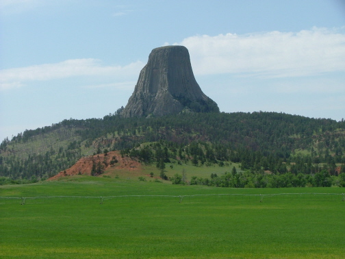
Ever since seeing the Spielberg movie, Close Encounters of the Third Kind Steve had always wanted to see Devil's Tower in person.
It's an amazing remnant of past geologic activity, and as yet none of the two or three competing theories of its genesis has been declared the winner.
What is clear is that it is formed of volcanic basalt that cooled slowly, forming gigantic hexagonal and octagonal pillars of rock that stretch unimaginably upward.
It's also clear that actors Richard Dreyfuss and Melinda Dillon could not have climbed to the top as they did in the movie without the benefit of technical mountain scaling equipment and skills.
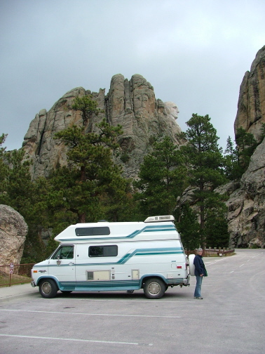
Rather than include a photo that would appear the same as most post cards and other commercial shots of Mount Rushmore, we offer this side-view taken along the route that climbs up behind the famous sculptures. From this angle, only Washington's profile is visible.
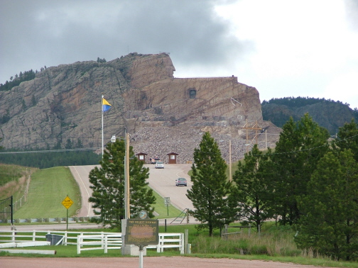
Not far from Rushmore, is the even more ambitious mountain-to-sculpture project which is attempting to create the image of Chief Crazy Horse, astride his horse, pointing toward the far horizon.
As you can see, the face of Crazy Horse has at least made its appearance from within the rock.
This is a family project and it is already in the hands of the second generation. It may well take a fourth or fifth generation to see the project to it's conclusion.
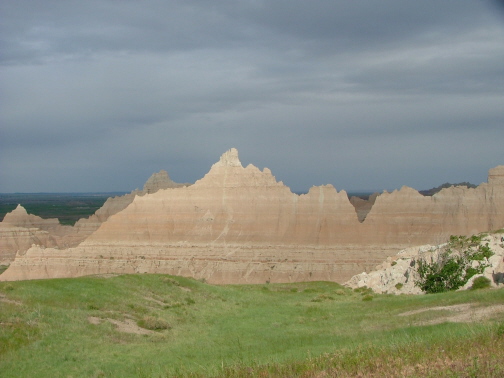
Another day and a half brought us to the South Dakota Badlands.
Like Utah's Bryce Canyon, the Badlands are a work in progress, changing so rapidly due to erosion that some differences can be noticed from year to year.
Much as the astronauts have described the moon, the Badlands are a magnificent desolation.
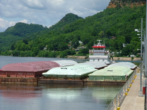
We were just about to leave Wisconsin and continue our journey eastward when we noticed this tug maneuvering the last six of its 15 barges into the river lock just downstream of downtown Trempeleau on the Mississippi. The lock isn't big enough to handle all 15 barges at once.
These "pusher" type tugs are amazing, managing somehow to control the three rows of five barges each that stretch out ahead of them for a distance that looks like the length of two football fields.
This particular lock was a bit of a challenge in that it required the tug to make a hard right turn immediately upon exiting the lock to avoid hitting a buoy directly downstream that marked a shallow mudbank.
The skipper had to exit the lock and then quickly reverse his engines to back upstream toward the dam to give himself room to make the turn.
The barges carry the equivalent of something like 250 rail cars.
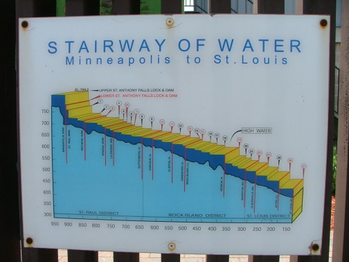
And, as you can see from the photo of this graphic, the tugs have to negotiate a large number of locks between Minneapolis, Minnesota and St. Louis, Missouri, while descending from almost 800 feet above sea level to about 400 feet.
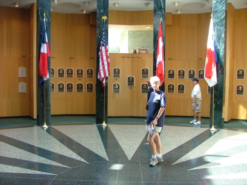
As luck would have it, one of the genealogical stops on Steve's history tour was within just a few miles of Cooperstown, New York, home of the Baseball Hall of Fame.
We spent an enjoyable couple of hours wandering through all of the exhibits and viewing the memorabilia.
Kay poses here in the main hall where the bronze monuments of the inductees are on display.
Rather than return home via our eastbound route, we opted to return home through the Canadian provinces.
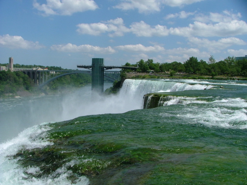
We crossed from New York to Ontario at Niagra Falls.
This shot was taken from an island in the middle of the river, right on the edge of the falls.
From here it seemed like it took forever to drive north and then west around the Great Lakes. Actually, it took the better part of three days to get through the huge province of Ontario.
We passed through Manitoba and Saskatchewan more quickly. We stopped for a break at a visitor's center just after crossing into Alberta.
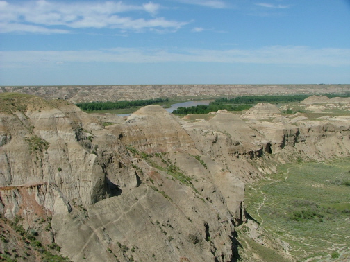
On one of their maps, we saw a provincial park not far off the main highway with an interesting name: Dinosaur Provincial Park.
We took the detour to DPP and were surprised to find this huge canyon hidden below eye level when driving through what otherwise looked to be flat prairie.
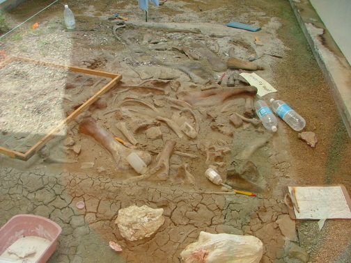
Aside from some stark but beautiful scenery, one of the attractions of Dinosaur Provincial Park is that you can go to see sites where actual dinosaur fossils are still resting in the ground where they were found.
There are so many dinosaur bones in the area that visitors are strictly limited on where they walk off the main roads. This is to protect the fossils from being inadvertently damaged or purposefully filched.
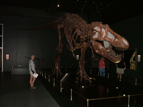
While at DPP we learned about the Royal Tyrell Museum in Drumheller, Alberta.
Once we saw this incredible place (we would need to create a whole new website to display all the photos we took) we were amazed that we had never heard of it before.
There are dozens of huge dinosaur skeletons like this Tyrannosaurus Rex on display here.
Plan spending at least six to eight hours, including lunch, if you come here.
One thing that becomes clear as you drive west through Alberta is that the Rocky Mountains are much more impressive when approached from the east.
This is due to the sudden, rather than gradual, rise of the Rockies from east to west caused by the manner in which the rock strata has been faulted and thrust upward.
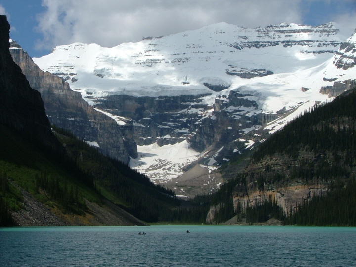
Here at Lake Louise in Banff National Park we could see many of these layers now thousands of feet above sea level where they were originally layed down millions of years ago
 .
.
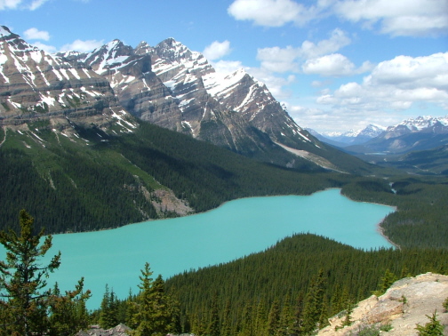
This lake further north and west of Lake Louise derives it's milky turquoise color from "rock flour" ground by the glaciers and washed downstream by their runoff.
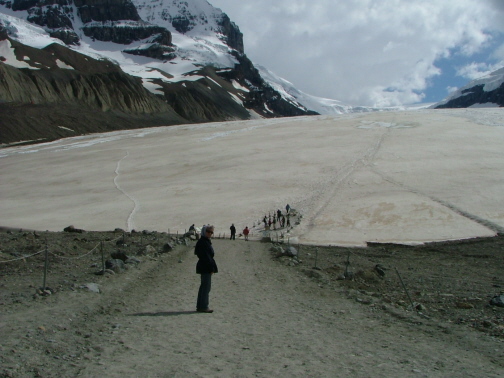
Further evidence of global warming is the constant retreat of Columbia Glacier.
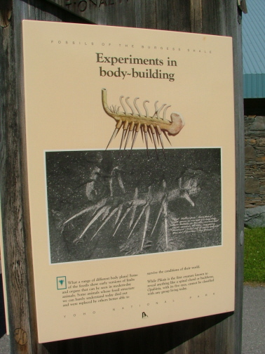
On the west side of the Canadian Rockies is one of the most famous geological formations in the world. It's known as the Burgess Shale. It was there that the sudden (in geologic time) explosion of life from the microscopic scale to the macroscopic was first discovered.
The majority of these bizarre early life forms, like the hallucigenia on the poster at left, became extinct. This guy was so strange that scientists still argue over which is right-side-up.
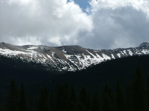
The Burgess Shale is the small, dark shelf of rock just above the snow line in the dead center of this photo.
Because of the uniqueness of the fossils and their scarcity, the area is electronically monitored and guarded. Hikes to the shale are permitted only with an official guide.
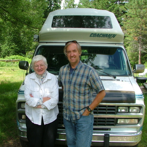
Perhaps this photo could have been put on the Magical History Tour page with the rest of the genealogical photos, but geographically it fits in with the road trip home.
This is Steve with another of his third-cousins, Irene Varty. Irene lives in Winlaw, British Columbia, Canada and was part of the reason we chose to drive west through Canada instead of the States. Winlaw was an easy side trip on the route home from Banff.
Steve and Irene share the same great-great grandfather, David O. Van Slyke.
Like their cousin Catherine Benjamin, in Salamanca, New York, Irene is also a serious genealogist and has done considerable work on her Van Slyke, Van Schaik and other family lines.
Irene, along with Miles Van Slyke and Catherine have provided Steve with several old photos and items of research of family members. And upon Irene's suggestion, Steve acquired History of the Bunn family of America which helped him put together some of the missing pieces of the Van Slyke - Bunn family relationship.
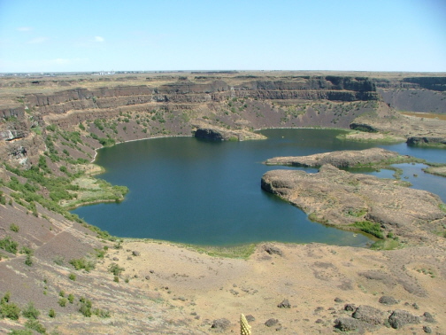
Our last sight-seeing stops on the trip were at Grand Coulee Dam on the Columbia River, and just below it a few miles at this formation known as the Dry Falls.
When a gigantic Ice Age lake in western Montana suddenly broke through its glacier dam, a torrential flood swept through Idaho and western Washingon leaving behind what are now known as the scablands.
This wall of basalt lava rock was, at that time, a monster waterfall as far as the eye can see.