BARRA LAGOON VIRTUAL BUOYS
(see photos at bottom of page)
The first time Kavenga entered the Barra Lagoon, we did it using the natural range and local knowledge guidelines, plus the radio assistance of crews already anchored in the lagoon. But once we were in the lagoon we still didn’t know the limits of the anchorage other than it was probably somewhat defined by the locations of the boats already anchored. And it seemed like at least one boat was running aground in the entrance channel every day.
We have a Piranha fishfinder for our inflatable and a Garmin handheld GPS. So in the spirit of Cook and Vancouver, we set out on Christmas morning to find out just how large the anchorage was, and where were the edges of the entrance channel.
These virtual buoys consist of soundings and corresponding GPS positions that were obtained on 12/25/2004 between 1305 and 1415 local time. According to one source, this timeframe corresponded to a tide range of +0.26 feet to -0.30 feet. So, for all practical purposes, it was a zero tide (just dumb luck, not design).
All latitudes are 19 degrees, 11 minutes plus the fractional minute.
All longitudes are 104 degrees, 40 minutes plus the fractional minute.
To save keystrokes, only the fractional portions are given in the positions below.
The waypoint ID numbers are the arbitrary numbers assigned automatically by our GPS and have no inherent meaning, other than it would make correcting and referencing them easier if any users should find significant discrepancies
CHANNEL WAYPOINTS
The following pairs of waypoints mark the approximate opposing edges of the channel leading into the lagoon anchorage. They start at a line drawn from the inner marina jetty to the point directly across from it. All soundings were 10 feet or better. It was noted in our survey that the edges of the channel are fairly steep; i.e. you could "just miss it" or "just hit it" depending on luck. Plot your own waypoints centered between these and you should not have any problems.
Wpt. 90 - .731N, .830W
Wpt. 89 - .748N, .794W
Wpt. 88 - .633N, .743W
Wpt. 87 - .645N, .723W
Wpt. 86 - .557N, .666W
Wpt. 85 - .565N, .640W
APPROACHING THE TURNING POINT
The next two waypoints are for the edges of the channel just before you arrive at the point where you turn left into the anchorage, which is just as you become abreast of the nearest edge of the small island with the sandy beach on the right side of the channel. Another guideline for the channel is to center yourself between the fish pens on either side of the channel or to use the natural range consisting of the left tangent of the small island and the tallest palm tree in the far distance.
Wpt 47 - 8' sounding - .467N, .583W
Wpt 48 12' sounding - .488N, .560W
LAGOON ANCHORAGE BOUNDARY
The rest of the waypoints are all for 7' soundings; i.e. they approximately establish the 7-foot contour around the anchorage. The interior of the anchorage was not systematically sounded, so it is possible there could be a "hump" or two in there somewhere. However, the anchorage was full—nearly 30 boats—when we did this survey and did not hear of any high spots. The anchorage itself has soundings of up to 10 or 11 feet and gets progressively shallower as you approach these boundaries.
Wpt. 50 - .399N, .511W
Wpt. 52 - .301N, .461W
Wpt. 55 - .316N, .401W
Wpt. 57 - .306N, .295W
Wpt. 58 - .342N, .224W
Wpt. 60 - .415N, .223W
Wpt. 63 - .509N, .295W
Wpt. 66 - .558N, .390W
Wpt. 68 - .604N, .450W
Wpt. 69 - .649N, .507W
Wpt. 70 - .647N, .544W
Wpt. 72 - .587N, .519W
Wpt. 73 - .554N, .497W
Wpt. 75 - .529N, .485W
Wpt. 77 - .493N, .482W
Wpt. 78 - .482N, .506W
Wpt. 79 - .479N, .522W
The gaps in waypoint numbers are just soundings that were in a straight line between the soundings given and therefore not necessary to plot the 7-foot contour.
“BACK ALLEY” ANCHORAGE
One of the interesting things discovered in our survey was the existence of an anchorage area behind the fish pen on your left as you enter. To the best of our knowledge no one was using this area, probably because it was assumed that any area behind the fish pens was probably shoal. The “Back Alley” as we call it, is delimited by virtual buoys 68 through 73.
In order to get there you first need to come all the way into the anchorage area, turn left, go past a line through the fish pen and parallel to the channel.You can then turn left again into this area. You can continue back towards town until you reach a line drawn from the fish pen shack to the point opposite it (to the ENE). The alley appears to be about 300 feet wide and possibly 1000 to 1200 feet long. So if a few boats anchored single file down the centerline of the alley, there should be plenty of swinging room since not much scope is needed (100’) in the shallow water. We only had time to take one sounding within the 7-foot contour that was 9 feet, so more soundings would be helpful, but it looks usable if the rest of the anchorage is already crowded.
CON CUIDADO (CAUTION!)
All the usual disclaimers apply. Use these virtual buoys with caution, along with other sources; i.e. your depthsounder, your eyes, local asstance, etc. And remember, the lagoon bottom is not static. It continually changes with the exchange of tides, storms, etc. So what was true in December 2005 may not be true now.
If you have the means and opportunity, please take your own soundings and let me know how they compare. We found other "deep holes" near the anchorage but didn’t take enough soundings to know if there is a deep path to them.
Hopefully, these waypoints, or "virtual buoys" will take some of the guesswork out of the equation.
Fair seas,
Steve & Kay Van Slyke
Chris Stockard of the sailing vessel Legacy incorporated our virtual bouy waypoints into his comprehensive web page about Tenacatita and Barra de Navidad. If you're headed there for the first time you should definitely check it out: http://www.legacysailing.com/local_knowledge/tenacatita_and_barra.htm
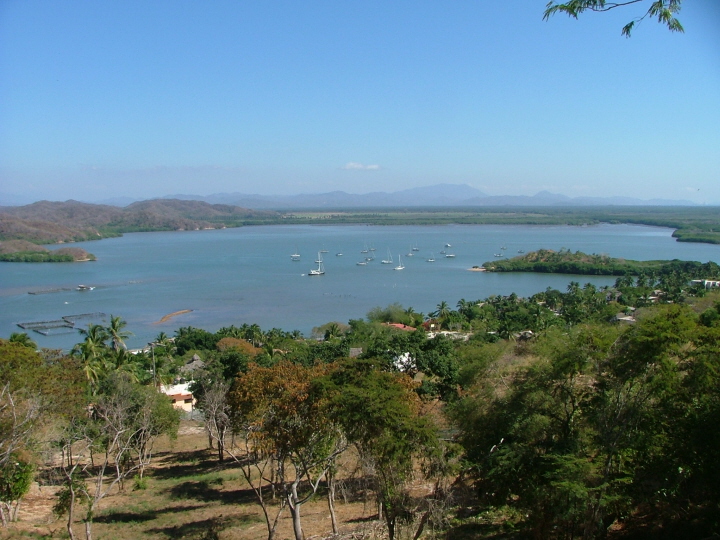
This photo gives you an overview of the lagoon and the anchorage area.
The entrance channel between the two fish pens is at left with a dinghy proceeding in mid-channel.
The island that is part of the natural range with the tall palm tree is immediately to the right of the anchored boats. The small sandy beach on the point is usually spotted easily. It is when abreast of this point that boats usually turn left into the anchorage.
The large boat with the dark hull that is closest in this photo is anchored in a questionable location. We took soundings of TWO feet barely a boat length astern of them. They said they were deep draft and didn't feel they could go further into the anchorage.
The Back Alley anchorage is the area bound by the far fish pen shack, the point of land beyond, and the anchored boats.
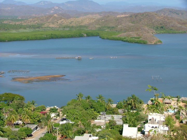
Here's a closer look at the entrance channel.
You can see from the photo that it is probably safer to favor the far fish pens than the closer one as you can detect the shoal that curves out toward the channel from the near pens. This shot was taken at low tide making the shoal areas more visible.
The Back Alley anchorage runs approximately from a line taken from the far fish pen shack to the point extending out from the far shore, and from there towards the main anchorage. It is perhaps 300 feet wide and 1000 to 1200 feet long.